Posts

Showing posts with the label Sedona

Gaia x GTFO = Discounted GPS!

gaiagps

Wandering the Munds Mountain Wilderness

Image
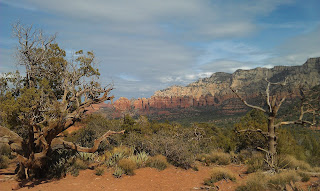
This weekend I decided to escape to Sedona for an invigorating hike alone in the serene beauty of the red rocks.  Before leaving I jumped on AllTrails.com to pick a destination, with length and novelty being a priority.  The trail listed as "Schnebly Hill Trail to Seven Sacred Pools," coming in at a lengthy 13 miles sounded like a winner.  Because, really, who can say no to not one, not two, but SEVEN SACRED POOLS??!!  I had never been there, but luckily the AllTrails app included Google Maps coordinates so I expected to be able to navigate from point A to point B with ease. 
Sedona hike: Little Horse Trail

Image
Little Horse Trail is a convenient hike with its trail head just past the Village of Oak Creek (the first town you pass if you are coming from the I-17).  The hike is fairly easy, with gradual elevation change and solid footing throughout.  For such an obviously located hike, the parking lot was almost empty and the trail was desolate when I hiked on a Wednesday; weekends will probably see a significant increase in traffic, though people may bypass this hike opting for the Chapel of the Holy Cross just up the street or the impression that they need to be more remote for a rewarding hike. View from the end. One of the "nuns" at sunset.  Contrary to any notion that you have to go out of your way for a rewarding experience, this hike culminates with of the more beautiful views I have seen in Sedona, but has only a few enjoyable views and photo opportunities on the way due to the trail being flat and shrouded by trees.  The hike is easy enough for even novices...

Day Trips: Jerome and Sedona

Image
Sedona's Rocks, from Jerome My friends and I have always said that the best part of living in Phoenix is that it is a great place to leave.  There are so many diverse destinations within a few hours drive that Phoenix is an ideal jumping-off point.  Jerome and Sedona are two unique stops within two hours if you take the interstate or about three and a half if you take the scenic route.  If you are unfamiliar with either town, they are each emblematic of the southwest.

Wilson Canyon Trail and Midgley Bridge

Image
Wilson Canyon Trail. Easy hike, pretty scenery but closed in and only can see views of Wilson Mountain. Photography Photography options generally limited to micro-scenic shots. Good hike to just look and enjoy nature with several opportunities to see interesting geological features in creekbed. Red Rock pass required, but available at parking area. Parking very limited. I was able to hike only about one mile into the canyon on account of time constraints, and with fairly frequent stops for pictures and generally enjoying the scenery it took me one hour for the 2 mile round trip that included only about 150 feet of elevation gain. The trail appears to stretch about another mile from where I turned around, and likely includes more elevation gain. This is a good hike for beginners and anyone hoping to hike in solitude. Despite, or perhaps because of, the crowded trailhead I saw only a mountain biker as I hiked. This can easily be hiked in sneakers and jeans if you didn't plan to hike...

Gaia x GTFO = Discounted GPS!

gaiagps