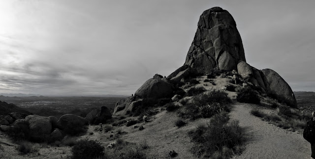
Hot Town Hikes: Tom's Thumb
Each edition of Hot Town Hikes will highlight one of the great trails in the city that is a convenient location and distance to get in a quick workout or nature walk along your commute.
A year or so ago one of Backpacker Magazine's local correspondents wrote about how Tom's Thumb is one of the best after work hikes in the valley. It's not a very conveniently located hike so for that reason I don't think of it as a great after work hike for anyone who doesn't live in or commute past North Scottsdale. But what it lacks in actual convenience it makes up for in its strategic advantage of being out of direct sunlight by evening.
Once you get to the trail head, Tom's Thumb has everything you need in an after-work hike or trail run:
- Plentiful parking
- Bathroom at trail head (no water though)
- Short-enough distance to finish before dark - approx. 4.25 miles RT
- Enough distance to feel like a workout
- Enough incline to get the cardio bumping - approx. 1250' aggregate elevation gain, 800' in the first 1.25 miles
 Getting to the trail head can be tricky if you're not paying attention to Google Maps, which might think the best way to get to Tom's Thumb is to route you to a random cul de sac then have you traverse, off trail, through the desert possibly trespassing. Just make sure you're going to Tom's Thumb Trail head (and as of this writing, simply searching for Tom's Thumb does take you to the trail head).
The trail itself is challenging enough for a workout, but not so challenging that a novice should steer clear. Aside from the slippery pebbles on the descent it's not technical. The only route finding necessary is reading signs at a couple of junctions. As long as you remember that uphill hikers have the right-of-way you'll find the trail is spacious enough, but there are numerous sections where someone is going to have to give way to oncoming traffic.
Tom's Thumb has one of the Valley's best payoffs for scenery. To the east: Four Peaks and Roosevelt Lake dam; to the west: skyline of the metro area. All around: mountains and desert scenery. With the right timing you might encounter desert wildflowers in bloom.
Be cautions of heat, dehydration, and rattlesnakes in warmer weather. Exercise caution and intelligence when hiking as the weather heats up. Know your limits, carry plenty of water, and know where you're going. Grab a map at the trailhead to keep track of where you are or sign up for Gaia GPS (discounted through GTFO links) to have detailed map access for this and other hiking trips. Keep in mind that it is illegal to hike with a dog on a City of Phoenix trail when the temperature is over 100 degrees. Even below that, it's important to know how to keep your dog safe on hot weather hikes.
Use Gaia GPS to plan this hike and more. Subscribe through GTFO for 20% off of memberships!


Comments