 |
| Snow covers the mountains and the trail, in May. |
Five years ago I was reluctantly celebrating my 30th birthday. As with most birthdays, I kind of didn't want much attention...actually, even more so since it was going to be a milestone birthday. To avoid attention I cashed in a groupon for a flea motel in Flagstaff, stopped at Chileen's on 17 for a chicken fried steak, then went by Babbit's to buy a birthday hammock ad hike recommendation. I wanted something solitary, beautiful, and relaxing. They came up with the Abineau Trail / Bear Jaw Trail loop on the north side of the San Francisco Peaks. I've been back many times since and haven't stopped being impressed.
In some ways I'm reluctant to talk about this hike because it's never busy and I don't want that to change--but the sometimes rough forest road and distance from Flagstaff (about 45-60 minutes from Downtown) as well as the lack of massive aspen stands like the more-popular Locket Meadow will probably prevent too much traffic. I don't think I've ever seen more than 8 or 9 cars in the parking lot, hopefully it doesn't change much.
Sign up here for a discount on Gaia GPS Premium!
This trail is a lasso loop that can be tackled clockwise or counter. While both directions offer a challenging elevation gain of 1920'. the counter-clockwise direction climbs that elevation over about 2 miles, while the clockwise direction spreads the work over about 4 miles. Either way, your legs are going to get a workout! It's up to you to decide if your quads are going to burn from pulling you up the mountain or from bringing you down.
 |
| Entering the aspen. |
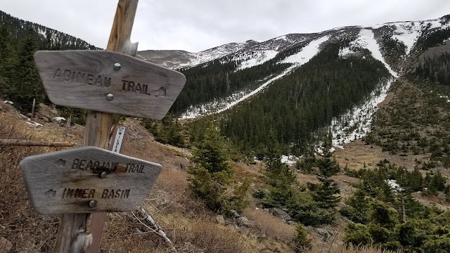
View wise, hiking clockwise is probably the better choice. Hiking that direction will take you through some small meadows before climbing into a few miles of aspen forest. This will all be along Bear Jaw Trail. About 2 miles into the hike you'll encounter the Waterline Road--a forest road that skirts along the mountain all the way over to the Inner Basin Trail if you go to the east (left). But take it west (right) to continue the hike a couple more miles to link up to Abineau Trail. You'll know the junction...it'll be the basin where avalanches have scarred the hillside up mountain and down--opening up views to the north, where if there's a clear day you can even see the Grand Canyon for much of the hike back to the trailhead.
 |
| The view north where Abineau and Watershed meet. |
Do be careful on the hike down Abineau Trail, though. That steep ascent you saved yourself from by going clockwise turns into a descent that'll take some attention to make sure you don't twist an ankle or slip. Slipping is especially possible here in the late spring, and even early summer, as snow frequently still covers parts of the trail; and snow melt can make things muddy and slick.
 |
| The view up Abineau Trail, snow patches strategically on the trail... |
I like this trail any time outside of winter. Spring and summer is a great escape from Phoenix heat--though you'll still encounter temperatures in the 80s at lower portions of the trail. In the fall you can frequently find yourself all alone in aspen patches that have turned golden.


Comments